See also the 5 live streams from Landgate building on July 31, 2023, on the Live streams page.
Live stream by Rod June 20, 2023
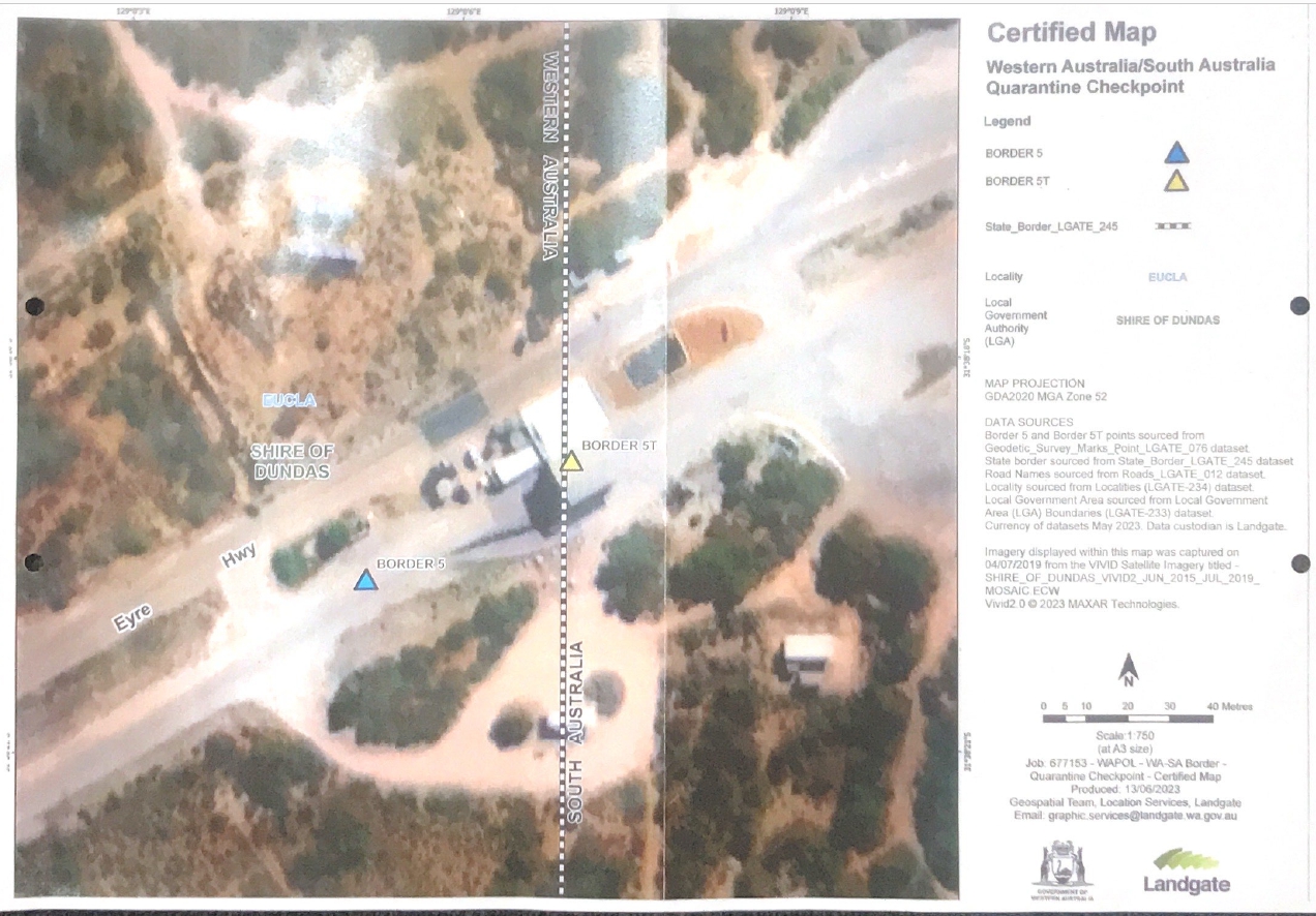
The “Certified” “map” produced as “evidence” of a survey line on the day.
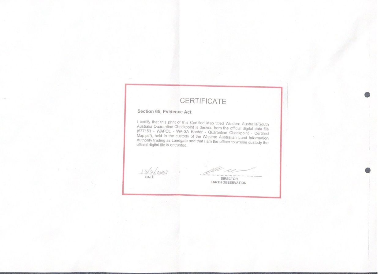
However, the law, and the actual evidence confirms the building is within South Australian jurisdiction.
Wikipedia
“The land border of the state of Western Australia (WA) bisects mainland Australia, nominally along 129th meridian east longitude (129° East). That land border divides WA from the Northern Territory (NT) and South Australia (SA). However, for various reasons, the actual border (as surveyed and marked or otherwise indicated on the ground) deviates from 129° East, and is not a single straight line.[1]
The Western Australian town closest to the border is Kununurra, which is about 25 kilometres (16 mi) west of the border with the NT. The settlement outside WA that is closest to the border is Border Village, SA, which adjoins the border; the centre of Border Village is about 250 metres (820 ft) from the border, on the Eyre Highway.
Border delineation
In some cases, the physical signage and structures that mark the actual border deviate from the 129th meridian. The Northern Territory border with Western Australia and the South Australian border with Western Australia are displaced east–west by approximately 127 metres (417 ft), as a result of errors caused by the technical limits of surveying technology in the 1920s,[1] when the current border was surveyed.
Consequently, since the 1920s, the border has included an approximate 127-metre (417 ft) east–west “dog-leg”, which runs along the 26th parallel south latitude (26° south),[1] immediately west of Surveyor Generals Corner – the point at which WA officially meets both the NT and SA. In June 1968, monuments were erected to mark both ends of this 127-metre (417 ft) east–west line.[1]
https://en.wikipedia.org/wiki/Western_Australian_borders
Commonwealth of Australia Constitution
123 Alteration of limits of States.
The Parliament of the Commonwealth may, with the consent of the Parliament of a State, and the approval of the majority of the electors of the State voting upon the question, increase, diminish, or otherwise alter the limits of the State, upon such terms and conditions as may be agreed on, and may, with the like consent, make provision respecting the effect and operation of any increase or diminution or alteration of territory in relation to any State affected.
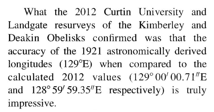 Journal of Spacial Science study 2014
JournalSpacialScience2014 (pdf)
Licensed Surveys Act 1909
3. Terms used
(1) In this Act, unless the context otherwise indicates, the following terms have the meanings set against them respectively: —
authorised survey — A survey of land authorised or required —
(a) under any Act dealing with the alienation, leasing or occupation of Crown lands, or under the Transfer of Land Act 1893, or any other Act affecting titles to land; or
(b) by the proprietor, lessee or mortgagee under any Act affecting titles to land, including —
(c) a survey of land which re-establishes the boundaries previously established by a survey of land so authorised or required, if that re-establishment —
(i) involves the placement, replacement or relocation of any survey mark; or
(ii) is followed by advice for the purpose of enabling the boundaries of the land in question to be located, or both so involves and is so followed; and
(d) the lodgment of a plan with a Government department or the Western Australian Land Information Authority established by the Land Information Authority Act 2006 section 5 for acceptance or adoption —
(i) as a plan of an authorised survey, if that plan is certified or otherwise held out as having been created from the result of an authorised survey, or as describing the boundaries of land within or the subject of that plan, which land is to be the subject of an authorised survey before that plan is approved under section 18; or
18. Plan to be approved by Surveyor General
An authorised survey, other than a survey referred to in paragraph (c) of the definition of authorised survey in section 3(1), shall not be accepted or adopted by any Government department or the Western Australian Land Information Authority established by the Land Information Authority Act 2006 section 5 unless a plan of such survey has been lodged with and approved by the Surveyor General or other person appointed by the Governor to approve plans of authorised surveys.
[Section 18 amended: No. 32 of 1994 s. 19; No. 79 of 1996 s. 16; No. 60 of 2006 s. 143(3).]
Australian Government Digital Earth Geoscience mapping
https://www.bitchute.com/video/MdAZgOaaWKCE/
South Australian Government region (jurisdiction of South Australian Police)
South Australian Government region on Planning mapping (jurisdiction of South Australian Police)
Google Earth
https://www.bitchute.com/video/GN1JzD2trRU6/
Google Earth screen share
https://www.bitchute.com/video/8IGLVPE8i98n/
Australian Bureau of Statistics boundaries
Google maps Street view with split screen
https://www.bitchute.com/video/DnyLvHRcvI8V/
Mapping on Bing
https://www.bitchute.com/video/5tn45On7DnEE/
Australia Post boundaries
Attempt to pervert the course of justice and conspire to defeat justice?